The first goal of Mappa Mercia was to map all roads within the motorway ring around Birmingham – a pretty big target, but one that we achieved by Christmas 2008. Since then we have pushed out beyond the motorways and created, what we believe is, the best road map of the West Midlands.
The project doesn’t stop there though! OpenStreetMap is much more than a road map. Any physical features present on the ground can be added to the map. Some of our current goals and projects are listed below. New contributors are very welcome to help us.
Don’t forget to have a look at the Mappa Mercia wiki page. The coordination and collaboration of the projects is happening there.
- Improving the coverage of buildings
- Identifying buildings
- Improving the 3D map
- Addresses and postcodes
- Mapping the Black Country
- Mapping footpaths
- Improving the cycle map
- Mapping education campuses
- Adding heritage data
- Adding bus routes and bus stops
- Entering turn restrictions
- Adding postboxes
- Making sure people can find shops
- Mapping regional urban centres
Improving the coverage of buildings
Birmingham is pretty much complete as far as building outlines are concerned but in the rest of the region there are hundreds of thousands to choose from for you to get on the map. Many of those already on the map can be improved now we have access to Bing Aerial Imagery and Warwickshire County Council Aerial Imagery. Many new buildings are being constructed and many are being demolished so there’s always plenty to do. Please be careful in slavishly tracing buildings from aerial imagery, it’s always best – and much more fun to edit from a ground survey.
Identifying buildings
Getting a building on the map is only the first step: many buildings have names, commercial and retail premises have occupants and almost every building has an address. Many buildings are sub-divided into units e.g. terraced housing.
Improving the 3D map
For the larger buildings, if you enter the height either by using the tag height = x where x is in metres or the tag building_levels=y where y is the number of floors you will improve the look of any of the 3D models generated from OSM data. Our favourite is at f4. Try this link to see the centre of Birmingham in glorious 3D.
Addresses and postcodes
We’d like to improve our coverage of addresses and postcodes – the more we have the more interesting and useful our map data becomes. To get anywhere near total coverage is a mammoth challenge so all help is greatly appreciated. By February 2014 we had 104,000 individual addresses.
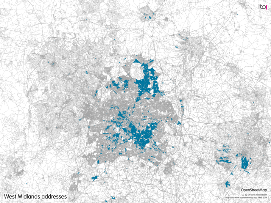
Pick a spot where you can see low coverage and start adding addresses (dark blue areas show addresses).
Mapping the Black Country
The Midlands would not be what it is today without the Black Country. Whilst the map looks pretty good for the Black Country, many of the roads need much better alignment with aerial imagery, and need a refresh in many places to take account of new road layouts. It would be good to get the major centres e.g. Dudley, Walsall, Wednesbury and the many “village” centres as nuclei of POIs and buildings.
Mapping footpaths
There are probably as many footpaths to map in the region as are already mapped. Many of those that have been mapped need to be identified as public rights of way. Because of the opportunity for country walking, this project attracts lots of attention. A map of Named long distance paths can be found here
Improving the cycle map
OSM has long been famous for the quality of its cycling data and there are several mapping systems based on it. However there are still gaps, particularly on the Black Country and there are always details that are missing, particularly the location of bicycle parking facilities, and of course the inevitable updates to the cycling route infrastructure.
Mapping education campuses
Several of the region’s University campuses are very well mapped, but many need completing, as do many colleges and schools. A high rate of change also occurs on campus environments, so there’s always work to be done in keeping the maps up-to-date!
Adding heritage data
The region has a rich collection of listed buildings, public artwork, memorials and blue plaques, for which there any many open data sets. Targeting heritage mapping objects gets you to all kinds of interesting places; noticing all kinds of feature that you just haven’t noticed; and discovering the region’s history. We’re particularly interested in photos (with a suitable opensource licence) for our heritage site.
Adding bus routes and bus stops
Many bus stops and bus routes still need to be added to the map, especially in the Black Country. Bus routes and bus stops change frequently so accurate data requires our constant attention. Have a look at the public transport map to see what can be done with public transport information in Openstreetmap.
Entering turn restrictions
If you want to use maps from OpenStreetMap on your sat nav you will want to have the turning restrictions for all junctions in the data. Routing engines can cope automatically where the turn restriction signs indicate no entry into a one way system the wrong way. It’s the others that traffic engineers have added to improve the traffic flow or prevent dangerous manoeuvres that are critical. There’s no other way of adding these than surveying them! You will need to know how to construct restriction relations. Help can be found here.
Adding postboxes
Under the Freedom of Information Act the Royal Mail has provided OpenStreetMap with a list of all their postboxes. Sadly, the locations are quite inaccurate so that all postboxes still need to be located exactly before they can be placed on the map. The list from Royal Mail can be accessed on this website. It also shows which postboxes have already been located.
Making sure people can find shops
A city does not only consist of streets, but contains points of interest like shops, pubs, and restaurants. Mapping these can be helpful to tourists to the West Midlands, for example, by helping them find the closest supermarket, or the area with the most pubs. But it is also useful to locals, who could search for a list of all furniture stores or electronic stores in a given area. The [POI Map](http://www.flosm.de/en/
Mapping regional urban centres
Several large towns in the region could do with some attention, such as Bromsgrove, Redditch and Rugby. This is not a criticism of what’s been done already, just that more people adding more data would improve things. This provides a great opportunity to go on some fully fledged mapping adventures. Suggest one for us to hold a mapping party there!